Sunday & Monday, January 25 & 26, 2015
Sunday we left Las Vegas and headed back to Bullhead City, AZ. We arrived in Bullhead City about 1pm. We got parked and settled.
This is our parking spot this time. The spot is not as level as last time.
We needed several things from the store so we went........
This is one of the casinos across the river in Laughlin, NV. It is actually a building made to look like a paddle wheel boat. Good job, huh! On to Walmart.
Tic went to the edge of the RV park after dark and got some pictures of the casinos on the other side of the river.
Above and below are some closeups of the a few of the casinos.
Monday we decided to take a short drive and hike to Christmas Tree Pass just outside Laughlin, NV to see petroglyphs we were told about.
As we turned off the highway onto the road to Christmas Tree Pass we saw this mountain. We thought it was interesting to see whitish rocks protruding in just a few places.
This is a closeup of the rocks on the right side of the picture prior. Below is a closeup of the other two peaks.
The protruding rock formation is of a very different type of rock than the rest of the mountain.
We were told to turn when we saw the sign for Grapevine Canyon. The Grapevine Canyon Petroglyphs are located in Grapevine Canyon on Spirit Mountain near Laughlin, Nevada.
The area is also known as Christmas Tree Pass.
While the petroglyphs extend through the canyon, a significant
concentration lies at the entrance to the canyon which is at an
elevation of 2,395 feet. The area features over 700 petroglyphs and many rock shelters.
We parked and took off. At the start of the hike was this sign.
Tic was intrigued with the color variations in this rock. It was about 18" on each side.
There were several unique rock formations along the walk beside the dry riverbed before we got to the petroglyphs. The picture above and the next several are of the walk to the petroglyphs.
The 3 rock formations above were just before the following picture.
This hillside was some rocks but mostly sand and gravel.
This is closer to rocks along the side of the dry riverbed. You can see Dusty walking.
At this point we had to head down into the riverbed.
This show the riverbed we are headed to.
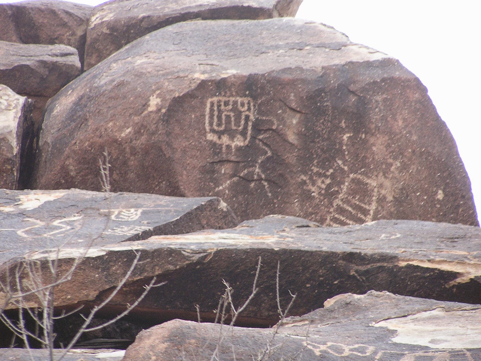
As soon as we got into the riverbed and turned the corner, WHAM there were petroglyphs everywhere. The rest of the pictures I put below are all of the petroglyphs we took pictures of. Most probably won't have comments.
You can see this rock in the prior photo. Dusty climbed up to get a closer look.
This is the last picture we took. It is the actual rock that was in the picture at the beginning of the trail. Per Wikipedia, the glyphs were created between 1100 and 1900 AD. Both the meaning of the glyphs and their creators remains unclear although the area was inhabited by the Mojave.
Friday, Jan 23, 2015
Today we leave for Las Vegas, NV for a Stream Business meeting tonight and tomorrow. New services becoming available. It is EXCITING!
Crossing the Nevada border. All the hills and mountains are sand and gravel and mostly barren of vegetation.
We parked at Riveria RV
Park. It is part of our Coast to Coast membership. The park had about 6
spots for short term visitors. Otherwise it was full of what looked
like permanent people. Some were pretty trashy. We did not take pictures of that. Our parking spot was wide and level and long enough. We got to sleep in our own bed and much cheaper than staying at the MGM Grand.
In Las Vegas we saw these fake palm trees that were really communication towers full of antennas. Sure looks a lot better than a normal antenna tower.
Here we are at the Unleashed Stream 2015 event.
We met Tim & Zeem standing in line to enter on Friday evening. They are originally from Pennsylvania and have recently moved to Arlington, TX. They are both MDs in the business. It was fun getting to know them. Tic was exhausted and they forgot to tell him to smile.
Saturday during the day we attending a lot of seminars between 10 am and 4pm. Also, for attending this event, we were each given an android notepad with a 9.6" screen. It is cool. Stream is an awesome company.
Saturday night Stream had a party in the Hakkasan Club at the MGM Grand. It was a multilevel club. They passed out hor d'oeuvres, but drinks cost. It had a big dance floor and lots of people danced. It was fun to watch. We left by 10pm since we had to be on our way out of Las Vegas in the morning. Thanks Stream for a great weekend.
Tuesday, Jan 20, 2015
We decided to do some sightseeing today. We drove over to Davis Dam. Davis Dam is an earth and rock-fill embankment with a concrete spillway, gravity structure, intake structure and power plant. The dam was build to help control the water flow after Hoover Dam was completed. Davis Dam was completed in 1953. One of the main purposes for this dam was to produce electricity.
As we drove towards Davis Dam we were intrigued with how it seemed to be buried in a valley in the mountains.
Tours are no longer available so we just walked around. Tic made this panoramic from the parking lot. We were disappointed no water was flowing on the spillway. We did not take any more pictures of Davis Dam.
Next we headed to the ghost town of Oatman, AZ. We were told about gun fights on the streets. Also we were told to see the Hotel & restaurant in town. Upon researching on the internet we found that just a short distance south of our RV park we could take a dirt road to Oatman. Per the internet, the road is not maintained by the county and can be rough but the scenery was supposed to be beautiful. We decided to take that route.
It is a slightly overcast and windy day so you see the dirt in the air. We stopped on the road and Tic took several panoramic pictures of the mountain range in the distance. This picture above and the two panoramics below go from left to right. It was gorgeous.
These pictures don't do the awesomeness justice.
We were headed into the south end this range. We are going from 528 ft elevation up to 2700 ft elevation in Oatman, AZ.
This is the road we stopped on for Tic to take the above pictures. This part of the road was nice and wide. About half the length of the road was about half the width of this road. It got pretty windy and hilly. I could only drive between 15 - 30 mph. It was fun.
This is just another unique peak on the way to Oatman.
The light color in the middle of this ridge looks like some rocks broke off at the top causing an avalanche.
This peak looks unique with half of it dark and the other half light in color. There were even several houses (5 maybe) where people were living "off the grid". Oatman started life over 100 years ago as a mining tent camp, and
quickly became a flourishing gold-mining center. In 1915, two miners
struck a $10 million gold find, and within a year, the town's population
grew to more than 3,500. In 1921 much of the town burned down. Then in 1925 the gold mining company closed its doors for good. The town died quickly. We figure these people living "off the grid" must be gold mining. It is fun to think that.
Apparently the burros used during the mining days were abandoned. The burros walk freely on the street. You can buy food to feed them, so they are fairly domesticated.
As we are walking down the main street, we saw people gathered and burros in the street and traffic at a total standstill. Even the UPS man had to stop and wait. We walked on past the traffic stop and saw that a staged gunfight was in progress.
This is the bank robber with the bag of money he just stole.
The man in the middle of the group is the sheriff. Of course the sheriff won the shootout!
More burros. I watched one burro pull a bag out of a woman's purse. The burros can be aggressive.
Here is the hotel and restaurant. We decided to have lunch inside.
I know it is a little blurry, but the information is fun. Among other things, it says that Clark Gable and Carole Lombard spent their honeymoon upstairs.
The walls and parts of the ceilings were covered with one dollar bills. Some of the original ones were laminated as you can see above.
Yes, those are all one dollar bills all over the place.
Even more dollar bills! We could not even begin to guess how many dollar bills there were.
It is not even a weekend and we had a live musician. He was actually pretty good.
After we ate we proceeded down the street to see what else we could see. Do you see the clock with dynamite on each side?
Behind that little "store" was this old abandoned mine. See the sign. A closeup of it is below. Also notice the doorway to the left of the sign.
This is the sign I mentioned above.
This is a closeup of the doorway to the left of the sign above. Cute.
I guess the guy in the picture above did not pay attention to this warning sign. Ha! Ha!
Around the corner they did have this short tunnel supported so you could walk through it and get the feel. Tic used a flash so it looks light but it was actually pretty dark.
More burros. I bet if you live in town they are a real nuisance.
A collector drove this restored Corvair while we were there. We had seen all we could so decided to head home a different route.
This route actually had paved roads. These are a few unique formations a little ways out of town.
The drive back was longer but actually took less time. Pavement made a big difference.