Total Pageviews

Monday, June 30, 2014

Keweenaw 3rd Excursion

Sunday, June29

Sunday evening after I'd finished the last blog, Tic saw this beautiful thundercloud.
What a view from our backyard.
Then this guy and his dog appeared on the water.  We were not sure where he came from and he took off down river.  We never saw him again.

Monday, June 30

Today we decided to drive up the other side of the island towards Copper Harbor.  We took the road named Gay Lac La Belle.  Today Tic drove and I took pictures.  I did not do bad.
These flowers are along side the roads much like our Texas bluebonnets. We are not sure what these are, but they grow in both blue and pink.
Here is a closeup of the pink ones.
Now don't jump to conclusions.  The bar and the town are named after a prominent person of the time.
This is the Gay Bar.  Pink paint but very straight.
This tells about the town, how it got its name and how it grew and declined.
This was the town school.  It is being refurbished and is supposed to be open to the public on July 4 for the first time in many many years.
There was this pavilion that had at least 3 carvings on each of the posts.  I'm only going to put in some of them.


There was not any info about the artist that did the carvings.  Whoever it was has talent.
The smoke stack above is all that remains of the Mohawk Stamp Mill. 
As we went further down the road we came upon Tobacco River Park.
This is Tobacco River flowing under the bridge and on into Lake Superior.
Here is the river flowing into Lake Superior.  All the countryside up here on the upper peninsula of Michigan is just awesome.
I was hoping to show the varying colors of the water but it does not show all the colors so I will have to explain.  Close to the shore it was so shallow that the sand was churned up and it looked brown.  Then the water went from light blue to medium blue to dark blue.  Wish I could have gotten the colors to show.
Further down the road was another park we couldn't pass up.
This is the beach.  You can see how far out it stays shallow.
It was a pretty windy day.  You can see how big the waves were.  The varying shades of blue show a little better in this picture.
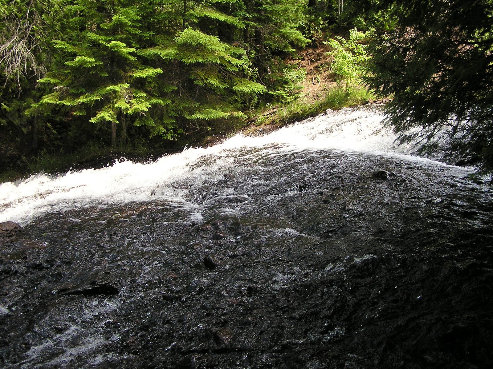
As we came into the town of Lac La Belle, we stopped at a pullout and then saw the waterfall below.
We are constantly amazed at the beauty we are surrounded by.


Copper mining was big from the mid 1850's to the early 1900's.  Tic was holding the sign because the wind was making it swing.
Here is more about the Central Mine.
This little house is now the visitors center; however, it was originally a miners home.
Across the street from the house above was the Central Memorial Garden.  
It was a pretty garden with a couple of benches around.  You cannot see any of the benches in this picture.
These pipes and concrete rocks were the hoist anchors for the Central Mine.
We drove on up this road thinking we might actually find the mine.  We gave up before we found it.


Then we came across Cliff Mineon Cliff Dr. 
We continued on Cliff Dr and only saw piles of rocks.  We presumed that was where the mine used to be per the above sign.  We took a different route home.  Many hills and trees. 


After dinner at home, we sat in our backyard.  This was the sunset about 10:15pm.  It stays light so late up here.


Sunday, June 29, 2014

Houghton, MI 1st excursion

Friday, June 27

We decided to start our day with a pasty [pronounced past(short a) e(long e)] from Roy's for breakfast.  Apparently pasties are a staple here in Michigan.  A pasty is pie crust type pastry usually filled with meat, potato, onion & rutabaga.  However, for breakfast we had one filled with egg, sausage, cheese & potato. The pastry seemed too thick and was dry.  We were not impressed.  I forgot to even get a picture of the pasty.  We walked back home.  Roy's was just down the street from the campground.

There is a people only ferry that leaves Houghton and goes to Isle Royale National Park. 
The island is 45 miles long and 9 miles wide, with an area of 206.73 square miles, making it the largest natural island in Lake Superior.  "Isle Royale is a rugged, isolated island where wolves and moose abound, far from the sights and sounds of civilization. Surrounded by Lake Superior, Isle Royale offers unparalleled solitude and adventures for backpackers, hikers, boaters, kayakers, canoeists and scuba divers."  The boat ride from Houghton is 6 hours.  The boat leaves on Wednesday & returns on Thursday, then leaves again on Friday & returns on Saturday.  That is the weekly schedule.  When we were walking to Roy's for breakfast, we got to see the boat leave.  As it went under the lift bridge, the bridge had to lift.  Below are several pictures.
The middle blue section is raised just before the boat goes thru.
Here is the boat directly under the bridge.
The boat looked like it had only a few passengers.

After we got back home we decided to take a drive along the north coast of the peninsula all the way to Fort Wilkins just past Copper Harbor.


I drove and I stopped at almost every historic spot.  This is the old train depot at Lake Linden.


This is Sandhill Lighthouse.  It has been made into a bed & breakfast.


We passed this house on the coast and had to take a picture.  It is a really neat looking house.
Next we stopped at Eagle River Township. 
There was a waterfall on this part of the Eagle River.

At the waterfall we turned around and this was the bridge support for the road we just crossed.  It is beautifully made.
Here the sign about the above bridge.


We are driving along the coast of Lake Superior.  We stopped because it looked like several shades of blue.  I stopped at a little pullout so we could check it out closer.
There are actually small pebbles of different colors in a pattern sort of.
Here's a better picture showing the varying colors.  Beautiful!
This view is at the Eagle Harbor Lighthouse.
Here is the lighthouse.

From the deck at the Eagle Harbor lighthouse I could see this house that looked like it was on an island.
This is a zoomed in picture of the house shown above.
As we drove down the street I saw a sign for the Eagle Harbor Life-saving Station, so turned.  Here it is. It turns out this was the "house" I thought was on an island.
This is a closeup of the Eagle Harbor Lighthouse from the Eagle Harbor Life-Saving Station.
Here we go, another stop because of this sign.
This is from the bridge over the Silver River Falls.
Here is the view from the top of the Silver River waterfall.
Here is the view just below the Silver River falls.

We came to a split in the road and chose to take the Brockway Mtn drive.  That was the best choice!!  At the top was this sign and the next 2 pictures below.
The whole area we've been driving thru had several copper mines.


The panoramic views were mind blowing.  It is such a blessing to be able to see so much of God's glory standing in one spot.
This view shows an inland lake with Lake Superior on the top right.  That little bay at the top left of this picture is where the Eagle Harbor Lighthouse and Eagle Harbor Life-Saving Station are.

From the top we can see this freighter.  Per the signs around it says there are 2 channels one 5 miles from shore and the second 10 miles from shore.  This ship must be 5 miles out.
This is another inland lake.  It is amazing how many lakes there are inland from Lake Superior.
At a pullout on the way down the hill, we saw this place way across the valley.
I thought this was a cool view.  The water to the right is an inland lake called Fanny Hooe Lake.  The water to the left is Lake Superior. 
This overlook had gorgeous views!  We are really in God's country.
Looking over the east end of the town of Copper Harbor.  Look to the top right side of the picture at a lighthouse.
This is zoomed in from the overlook.  We did not drive out to this lighthouse.
Looking over the west end of Copper Harbor.
Look closely and you can see several kayaks.
This the the whole Lake Fanny Hooe partially shown in a previous picture.  This picture is taken from the same overlook.  Lake Fanny Hooe is just inland from Copper Harbor.
These were some pretty flowers growing at the Copper Harbor Overlook.

Next we drove into Copper Harbor.  It was a quaint little town that looked poor.
We did see this patch of poppies growing.  We got several pictures.
Aren't they beautiful?
Here are some buds about to open.

Next we drove on to Fort Wilkins Historic site where they rebuilt the various structures.
This is how the fort was laid out.  All the buildings were rebuilt.
This is the row of housing for the infantry.
Here is the parade grounds in the center of the compound.
The two pictures above are the officers quarters, mess hall, security/jail and meeting hall.
This road is part of the direct route we took back home.  We took 4.5 hours getting to the northern most point of Fort Wilkins and only 1.25 hours back home.  

We both feel so blessed to be able to travel like we are and see so much of God's glory.  This far north the days are really long.  Sunset tonight is 9:55pm